secret SIte x
|
One of the most common beliefs of the fate of the colonists of Roanoke is that they assimilated into local Native American culture. A map, drawn by none other than John White himself, ultimately led to the discovery of Site X and one of the biggest advancements in the mystery of the Lost Colony of Roanoke. White began to draw the map in 1585, but it wasn't until 2012 that the secret Site X was found. At the time of the map's creation, mapmakers would use pieces of white paper to cover up mistakes or make changes in their map. This is exactly what John White did; in 2012, researchers used x-ray technology to discover a red and blue star on his map, La Virginia Pars. The star was located approximately 50 miles inland and Site X was born.
|
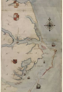
La Virginea Pars by John White. 1585. Public Domain.
|
Discoveries at site x
|
Since the beginning of the excavation of Site X, there have been a plethora of discoveries that lead researchers to believe that The Roanoke colonists may have moved to assimilate with a tribe at this location. Here, are just a few of the items that have been found:
|
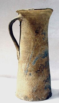
Coarse Border ware conical jug by an unknown author under CC BY-SA 4.0
|
references
Basu, T. (2013, December 9). Have We Found the Lost Colony of Roanoke Island? Retrieved from https://www.nationalgeographic.com/news/2013/12/131208-roanoke-lost-colony-discovery-history-raleigh/
Pruitt, S. (2015, August 10). Archaeologists Find New Clues to "Lost Colony" Mystery. Retrieved from https://www.history.com/news/archaeologists-find-new-clues-to-lost-colony-mystery
Pruitt, S. (2015, August 10). Archaeologists Find New Clues to "Lost Colony" Mystery. Retrieved from https://www.history.com/news/archaeologists-find-new-clues-to-lost-colony-mystery
